Delivered on


We offer a range of cutting edge drone survey services using LiDAR as well as photo and video. These include 3D UAV LiDAR mapping, topographic land survey, DEM Survey, 2D orthomosaic, volume calculation and contours. Then there’s digital twin measured building surveys, drone roof inspection and construction site project progress monitoring.
All data is delivered in standard file formats thus offering maximum compatibility. Drone LiDAR survey, aerial photogrammetry survey and digital twin model deliverables are accessible via the Rock Cloud or Pix4Dcloud. These platforms offer access to data downloads and online tools for measuring distances, heights and areas directly from the point cloud and/or orthomosaic. As well as taking measurements there are tools for analysing DTM / DEM.
Drone LiDAR Mapping for the Ultimate Topographical Survey
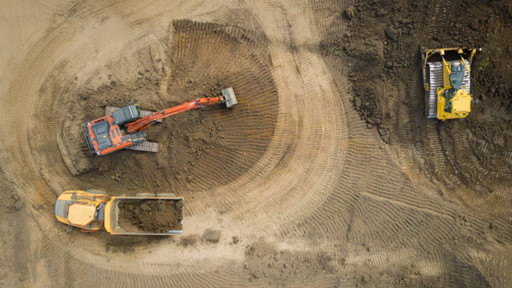
Drone LiDAR mapping offers the ultimate topographical survey. With 1500+ points measured per square metre and the ability to see beneath vegetation, the point cloud that is produced has a phenomenal level of detail. This model provides the basis for stunning DEM data and DXF contour files. Highly accurate large and small scale volume calculations are also possible and through complimentary access to the Rock Cloud platform clients can measure heights, distances and areas in just a few clicks. All of the following data can be provided through a single drone flight:
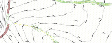
Topographical Survey
Topographical 2D CAD drawings in industry standard DWG format.
Elevation
Digital elevations models (DTM / DEM) for ground topography.
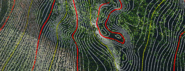
Contours Survey
Topographical contours in CAD and GIS formats.
DEM Data
DEM ground data delivered in the widely used TIF format.
Classified Point Cloud
Categorised data through ground classified LAS files.
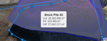
Volumentric Survey
Highly accurate volume / cut and fill / stockpile calculations.
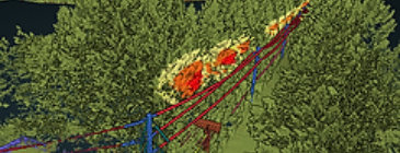
Vegetation Management
Overhead cable and power line rapid diagnoses of critical violations.
Aerial Photogrammetry
HD 2D orthomosaic project progress and planning imagery.
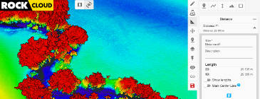
Rock Cloud
Complimentary online point cloud measuring and analysis tools.


Want to know how much an aerial survey of your site will cost? Get a price now by using our online quotation system, it only takes a few minutes.
Unique Turnkey Solutions
With our unique turnkey solutions for drone based LiDAR mapping and topographical surveys, not only can you arrange quotes and bookings online, but also receive your deliverables on the Rock Cloud too.

Request Quote
Firstly, request a quote with our online quote system and it will be e-mailed within minutes.

Book Visit
Secondly, accept the quote and receive a booking link to choose your preferred day for our site visit.

Receive Deliverables
Thirdly, deliverables are uploaded to our cloud portal or sent via e-mail usually within 4 working days.

We assist architects, surveyors and engineers with highly accurate scan to CAD and scan to Revit services using a combination of drone photography and terrestrial laser measurements.
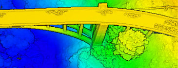
Digital Twin 3D Visualisations Will Bring Speed, Efficiency and Cost Savings to Your Construction Project
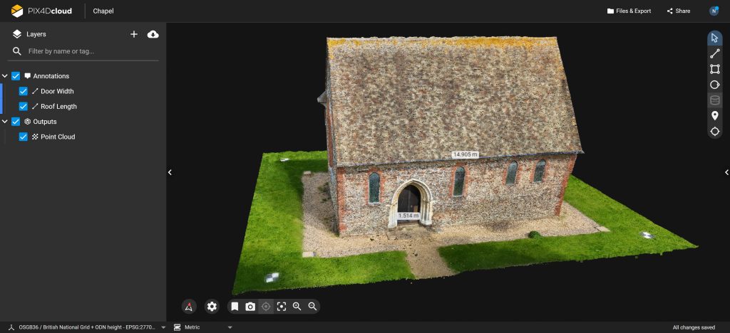
We assist architects, surveyors, engineers, contract administrators and private clients with digital twin models created using a combination of drone photography and terrestrial laser measurements. Creating models with these two technologies provides unparalleled levels of detail and accuracy no matter how large the building is or its shape and surroundings. It can also dramatically lower measured building survey costs. The dense point clouds and textured models we offer can be used in a range of software packages including AutoCAD and Revit as well as cloud based inspection and measurement platforms such as Pix4D and Nira. If you’re looking for a full end-to-end service, we can also provide scan to BIM 3D modelling as well as 2D drafting elevations and floor plans.


Why Choose This Service
- We bring the expertise and equipment, so you get cutting-edge 3D visualisation without the capital investment.
- As we work with many different platforms and technologies we are well placed to help you find the most appropriate one for your project.
- Scanning large buildings with drones can increase speed, accuracy and detail as well as dramatically lowering costs.
- Enhance your project with new levels of visibility, measurability and scalability.
- Leverage BIM data to make informed decisions and complete your project faster.
- Benefit from unparalleled levels of detail compared to traditional building survey techniques.
Pix4D Online Tools
- We can host your project on PIX4Dcloud where you can view, inspect, measure and annotate mesh models and dense point clouds via your browser.
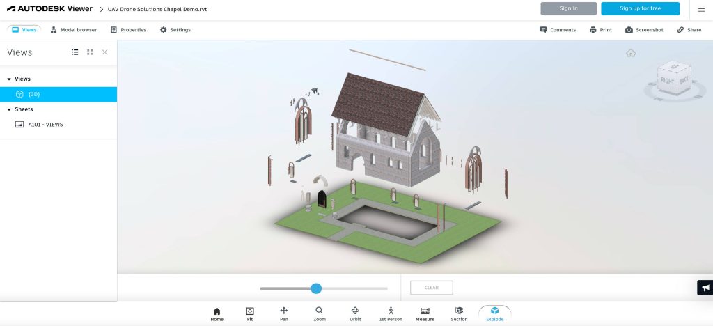
Autodesk
- The photogrammetric point clouds we create can be used in AutoCAD or Revit for 3D BIM modelling and 2D drafting. We can provide just a point cloud for your own CAD professionals to use or a full end to end service.
Want to know how much a a digital twin of your site will cost? Get a price now by using our online quotation system, it only takes a few minutes.
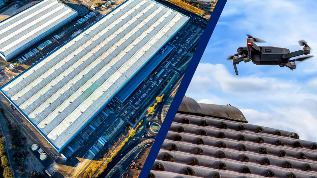
Roof Inspection and Construction Site Project Progress Monitoring
Drones offer a cost effective and safe way to undertake roof inspections. They are fast, efficient and do not risk damaging the roof while an inspection is taking place. For both residential and commercial properties we can provide a low GSD, high definition 2D orthomosaic of an entire roof and/or 4K video. For commercial inspections we can provide high absolute accuracy RTK positioned data. Inspection data is presented in an easy downloadable package.
We also use 2D photogrammetry to produce orthomosaic images for construction site project progress monitoring. This high definition geoloacated imagery can be used by the whole site team and to keep stakeholders informed. Other benefits include
- Helping to identify issues and potentially hazardous areas
- Ensuring compliance with safety standards
- Improving decision making
Alternatively or as an additional dataset, 4K video of can be shot of a whole site or particular areas of interest. All data collected is neatly packaged and delivered as a download.
Need a roof inspection or construction site progress monitoring? Get a price now by using our online quotation system.
New Ultra Fast Terrestrial Scanning Service
We’re now offering a terrestrial scanning service that provides fast ~1cm accurate digital twin models ideal for companies requiring:
- Utilities and subsurface mapping
- Construction verification
- Earthworks monitoring
- Civil engineering verification
- Small scale land survey
- Time and cost savings
- Cloud accessible BIM


Interested in this service? Contact us now for further information and to discuss your requirements.
Project Spotlight
From Aerial LiDAR Mapping to CAD/GIS Deliverables
Watch how we complete an aerial LiDAR mapping survey as well as a demonstration of the point cloud we produce. Then see the amazing cloud software with measuring tools that our customers get access to. Lastly we run through the CAD, GIS and classified LAS deliverables we can supply.


